The Ribble Way more or less follows the River Ribble from the mouth in Preston, Lancashire all the way up to the source in Ribblehead, North Yorkshire along 72 miles of trail. We were originally going to start in Preston like everyone else does and walk to the arse end of nowhere, but do you know how fucking difficult it is to obtain public transport back to the start in bum fuck Yorkshire? You can’t. It’s a void. A busless abyss. I asked Google how we’d make our way from the finish point back to Blackpool with various mass-human-shuttling modes of transportation and it suggested I drive a car. Helpful. We could have gotten a lift from my parents but we didn’t really know when we were going to finish and there’d be no way of calling them so we decided to blag a lift to the far end and walk back to Preston, the land of peasant wagons and obnoxiously expensive rail-based metal tubes.
My parents graciously drove us the probably about two hours from their home in Blackpool because they’re legends like that, and deposited us in a random car park in the middle of nowhere, and we wandered off into the wilderness, overstuffed backpacks strapped to our torsos, like we were off on our DofE about 25 years too late.
There are possibly closer places to be dropped off to access the trailhead but ideally we didn’t want to set foot on the Ribble Way until we were ready to start it so the car park we chose was just over three miles away along an easy tarmac road which does eventually give way to trail. We turned off and there were two couples sat having a break as another couple strolled in the opposite direction we were. It was like Piccadilly bloody Circus, all these people! I checked the map and yep, this was now the Pennine Way. Well, few metres of busy trail, we will be seeing you next year. In the meantime, we swung a right onto the Pennine Bridleway and followed that all the way to Gavel Gap, which is actually just a gate in a stone wall which serves as the end, or somewhat controversially in our case, the start of the Ribble Way.

The actual source though, you’ve pretty much got to gawp at it, it’s basically the law. If you’re approaching it from the side we did you need to go though the gate and up to the left where you’ll see a small trickle of baby river coming out of some rocks in a distinctly undramatic fashion. A very small trickle in our case, it’s been uncharacteristically dry up north recently but you can definitely see that there’s meant to be some manner of spring here. You do feel kind of underwhelmed, you want to be all like, “Yeah it’s the start of the River Ribble hashtag nature!” but there’s not really even anything to photograph. I mean, you can, but you’ll look at it a couple of months down the line and you’ll not remember why you took a photo of some grass and moss and rocks.

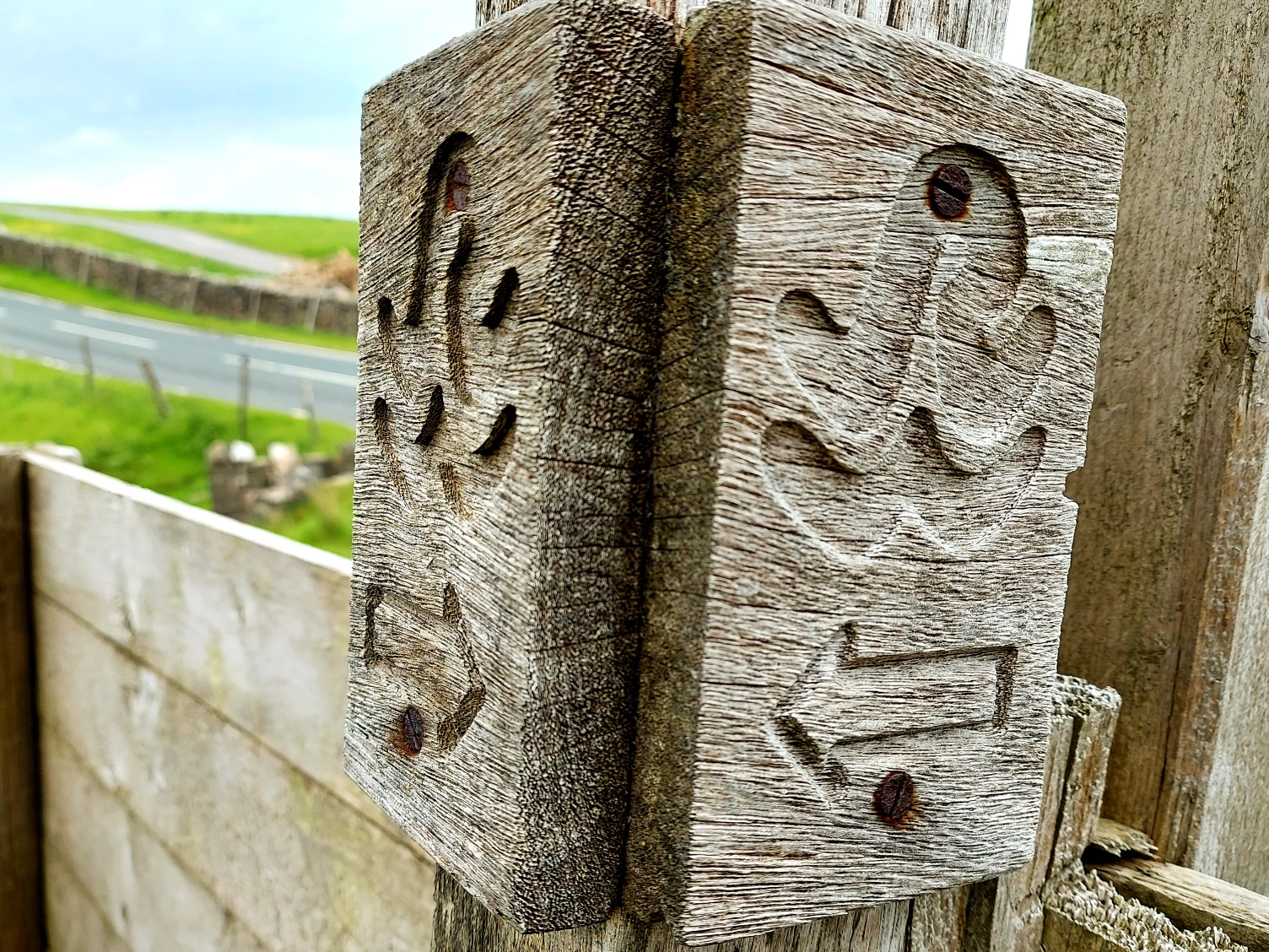
Right then. We got that out of the way and returned to the gate to get our adventure under way. Here’s a fun fact though; not only is there nothing to indicate you’re at the start of end of the Ribble Way, there’s nothing to suggest the fucker even exists. You’re still on the Pennine Bridleway by this point and there’s a waymarker announcing this, but nothing for the trail we wanted. This is the second time this has happened, we were a mile into the West Deane Way before the universe acknowledged its presence in the space time continuum. We were four and a half miles into the Ribble Way before we found the first waymarker, but what a waymarker! A lovely carved bit of wood with RW stylised to look a bit like a river. Nice. Looked expensive. No wonder they were being stingy with them. The lack of signage does mean you’ll need some manner of navigational device such as a map, or just memorise which of the other trails you need to be on and for how long, because it does seem if you’re on any other named trail the Ribble Way simply doesn’t get a look in, the poor bastard.
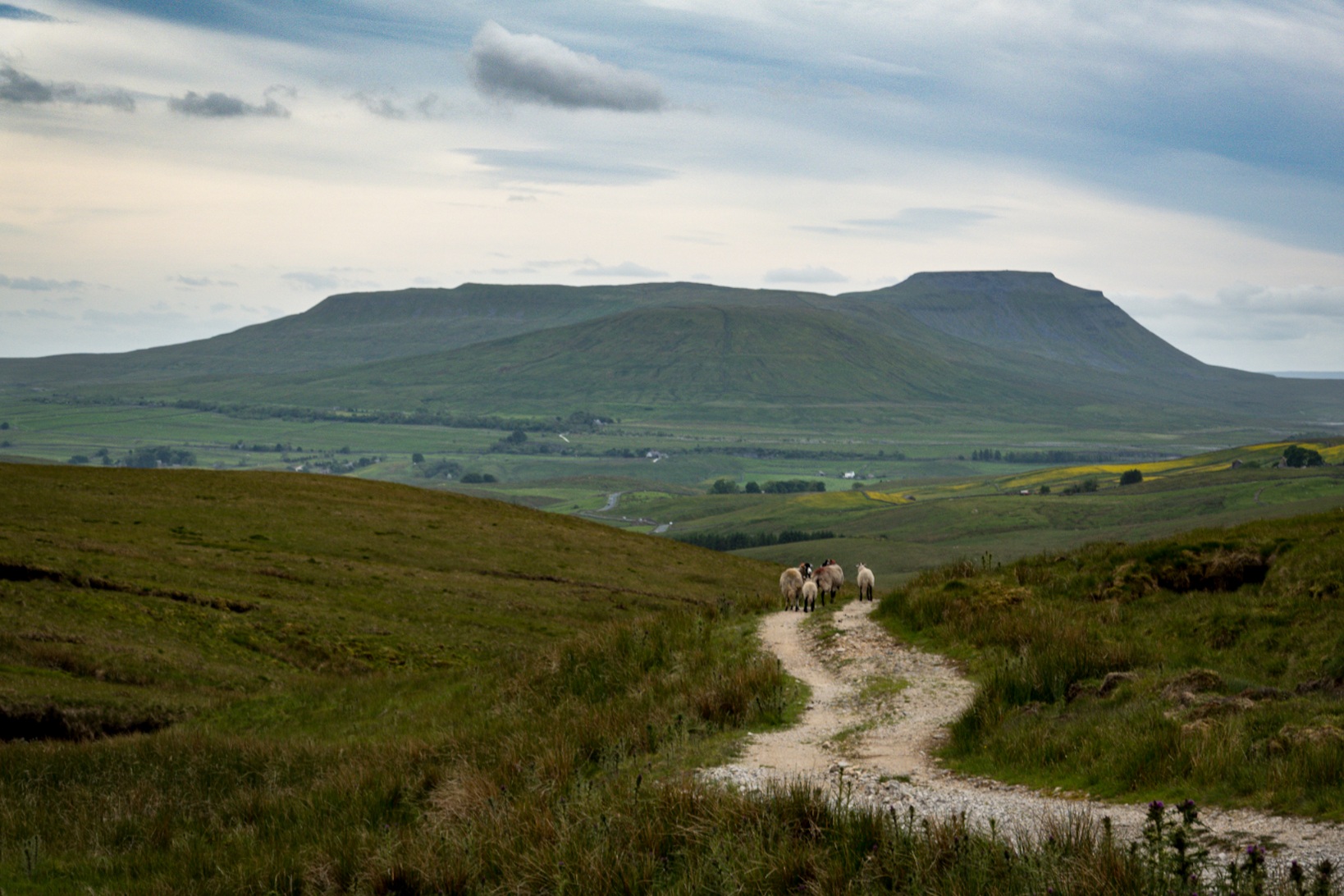
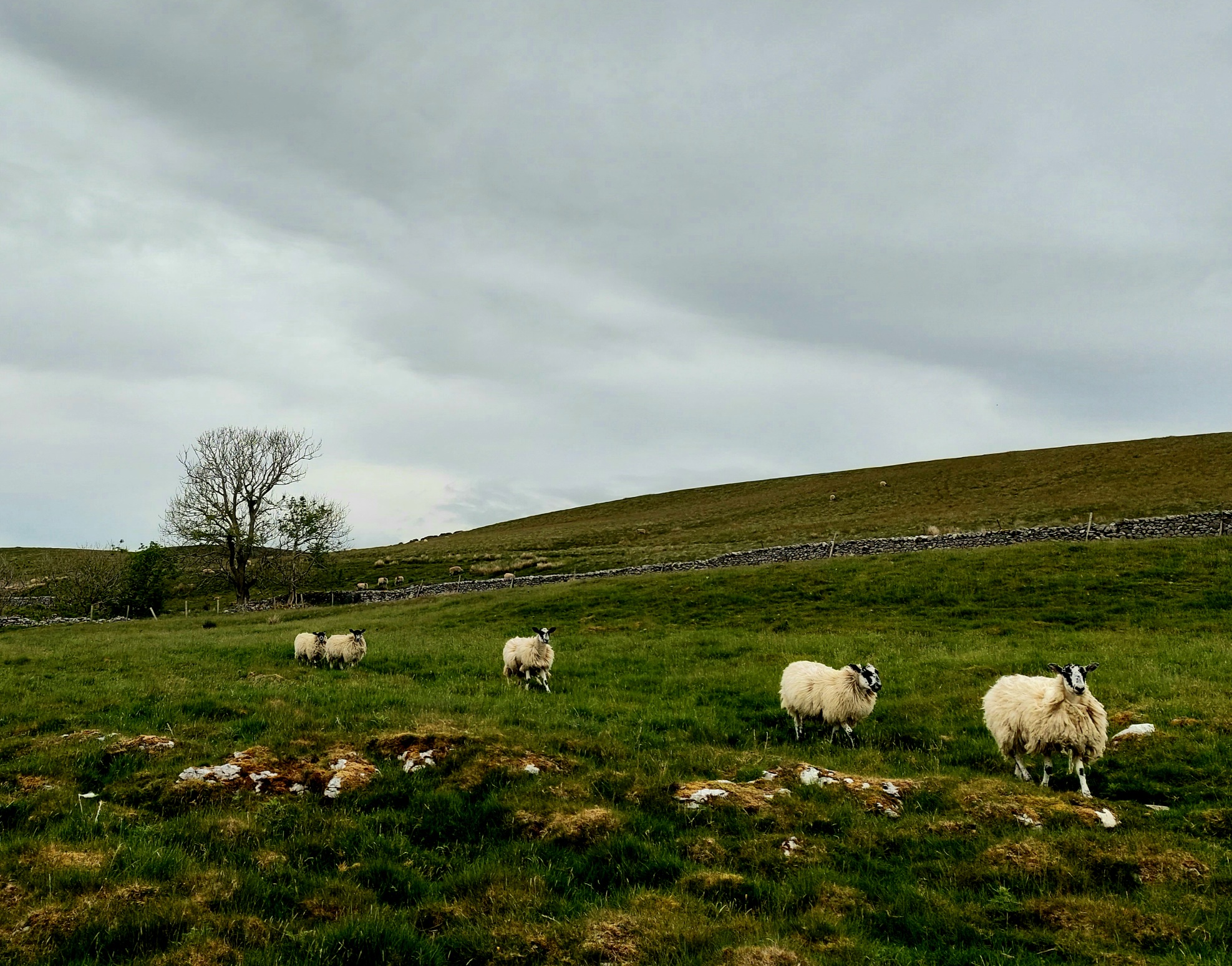
So today was largely two lesbians shuffling through North Yorkshire and stopping every ten minutes to exclaim things like, “Fuck me, it’s beautiful!” Your eyeholes will really appreciate this part of the world. There was one particularly sexy chunk of corrugated Earth crust which dominated the horizon for most of today so of course I became completely obsessed with it and couldn’t stop waving a camera at it. Big hill with sheep in foreground. Big hill with field in foreground. Big hill with girlfriend walking away from the camera in a casual fashion that suggests she doesn’t know a photo is being taken in foreground. I found out later it’s Pen-y-ghent which means we’ll be tackling that bad boy next year along the Pennine Way as part of our Eastbourne to Lands End to John O Groats National Trail crushing extravaganza. Yeah, I’m suddenly a lot less fond of it.
Aside from the scenery which will have you tripping up over your jaw there’s nothing overly dramatic about this walk so far. There are inclines and declines of course but nothing that’ll send your calf muscles into shock. There are many sheep. So many sheep. A lot of them have lockdown haircuts, like big chunks of wool hanging off them. These sheep look like they’re just about done with homeschooling and need a fuck off G&T just to get through the next hour. Tarrant did have to rescue one sheep, the poor bugger went and got its horns stuck in a gate as we approached. It must have been going for the delicious looking grass on the other side of the gate and panicked when it saw us and just couldn’t get out.

We couldn’t just leave it, god knows if or when it’d be found, aside from Grand Central on the Pennine Way we’d seen no other humans. I had a go at trying to release it but I couldn’t get it to stop thrashing for long enough and I didn’t want to trap my fingers between the metal and the freakishly strong, very scared ovine so Tarrant stepped in. We made what we thought were soothing noises to get it to stay still so she could manoeuvre its head through and that seemed to work, either that or the weird, pink bipeds making the horrifying shushing noises just freaked it out so much it froze in abject terror. She managed to turn its head sideways enough to push its horns through the gap without them catching and off it bolted as fast as its wooly little legs could carry it. I hope it’ll be okay and not too traumatised, bless it.

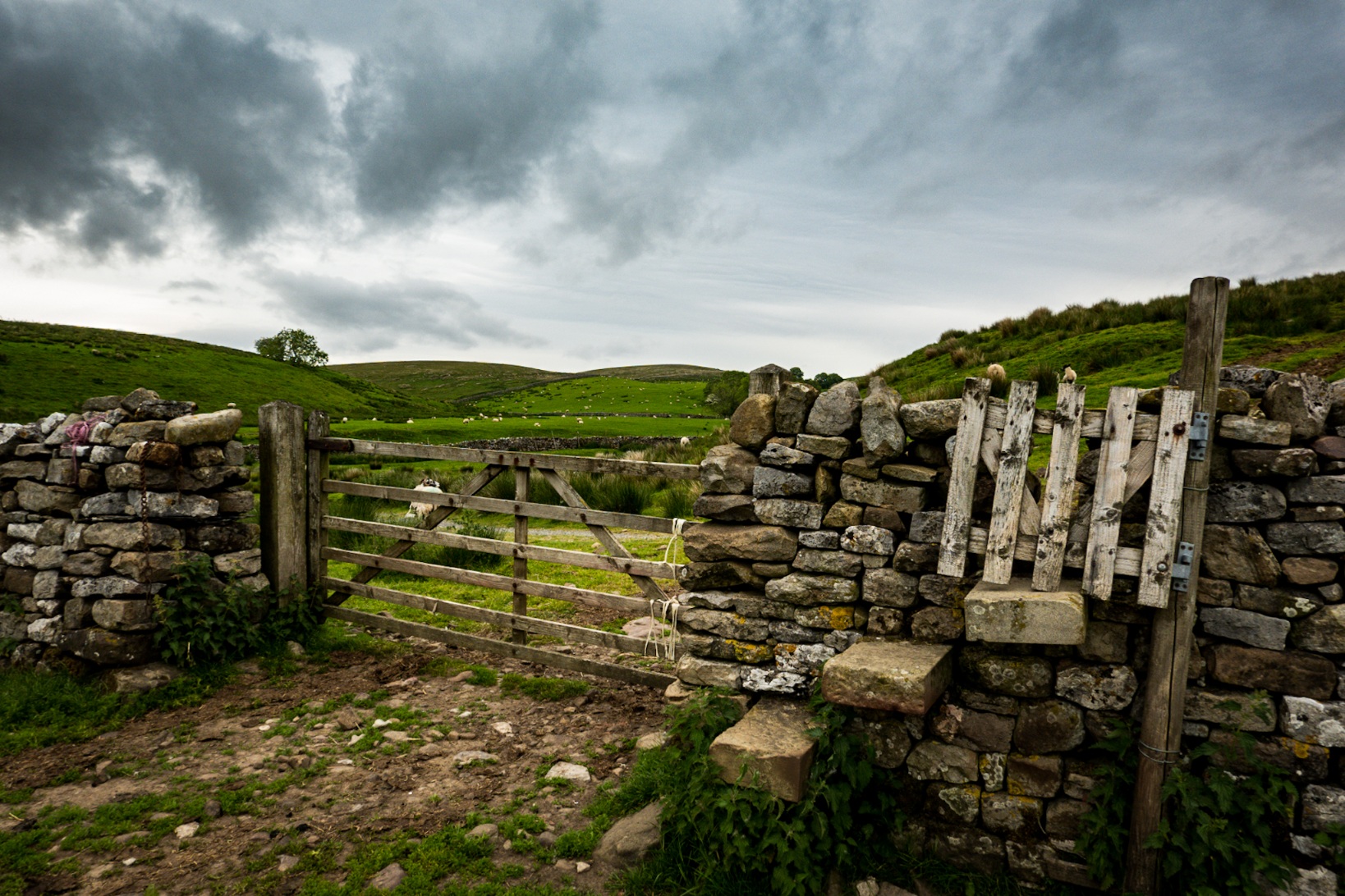
Talking of traumatic, Yorkshire I like you and all that and your stiles are very photogenic but they’re not very fucking practical for those of us with the balance and coordination of a drunk badger on stilts. They’re mostly slabs sticking out of a dry stone wall, sometimes with a tiny spring loaded gate which you have to try and get through without it trapping your legs. There’s not much to grab onto for balance either and you end up sort of clambering over the wall like a giraffe trying to mount a lilo in deep water, hoping your limbs obey your commands, and all whilst trying not to stack it and faceplant a pile of sheep shit. It’s extra fun when a bottom slab is missing. Bonus points if it’s booby trapped with nettles.
Something else that doesn’t aid grace and flexibility is opting to carry five days worth of food and snacks. You don’t need to do that on this trail, you pass through plenty of places with shops, we just wanted to see if we could. We could, but fuck me, it was 15.5 kgs with water! There won’t be many times when we need to carry that much, certainly not in the UK, but it’s good to know our knees didn’t go into complete rebellion when faced with the prospect, and at least it’d get easier as we munched our way through the load. It’s not our usual practice either, we prefer to shop locally wherever we can and I can’t justify treats like cake and ice cream when we have backpacks full of food we need to eat for the sake of our legs.

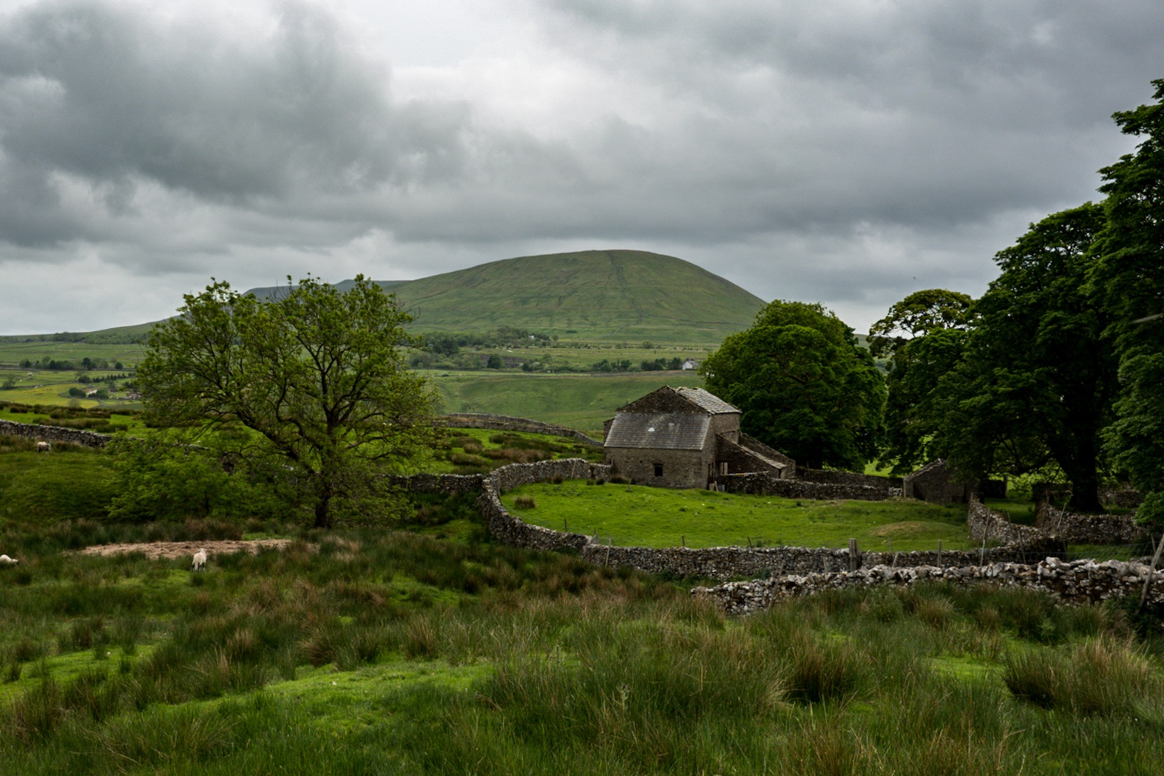
Along with sheep and dry stone walls with questionable stiles, another mainstay of the landscape here are the dilapidated barns dotted around the place. Are they falling down because they’re no longer in use? What were they used for anyway? I mean, sheep, obviously, but, like, at night? In bad weather? They don’t have roofs any more so they’d not do much to keep the rain out. They’re quite photogenic, but to be fair this whole swathe of county is photogenic as fuck. Like, there’s nowhere you can point your face and think, “Nah this is ugly.” It feels so sparse and uninhabited apart from the odd farmhouse. We had no phone signal and by the time we started looking for somewhere to camp we’d still seen no humans.
We were still very much on farmland by this point and as if to prove it the farmer and his dog were out on the quad bike, doing whatever it is sheep farmers do at 7pm. If we had the lady-bollocks we would have asked him if we could camp on his land but instead I just did that casual chin raise you do when you’re trying to cooly acknowledge a stranger whilst not looking suspicious. I’m not sure but he might have rolled his eyes.

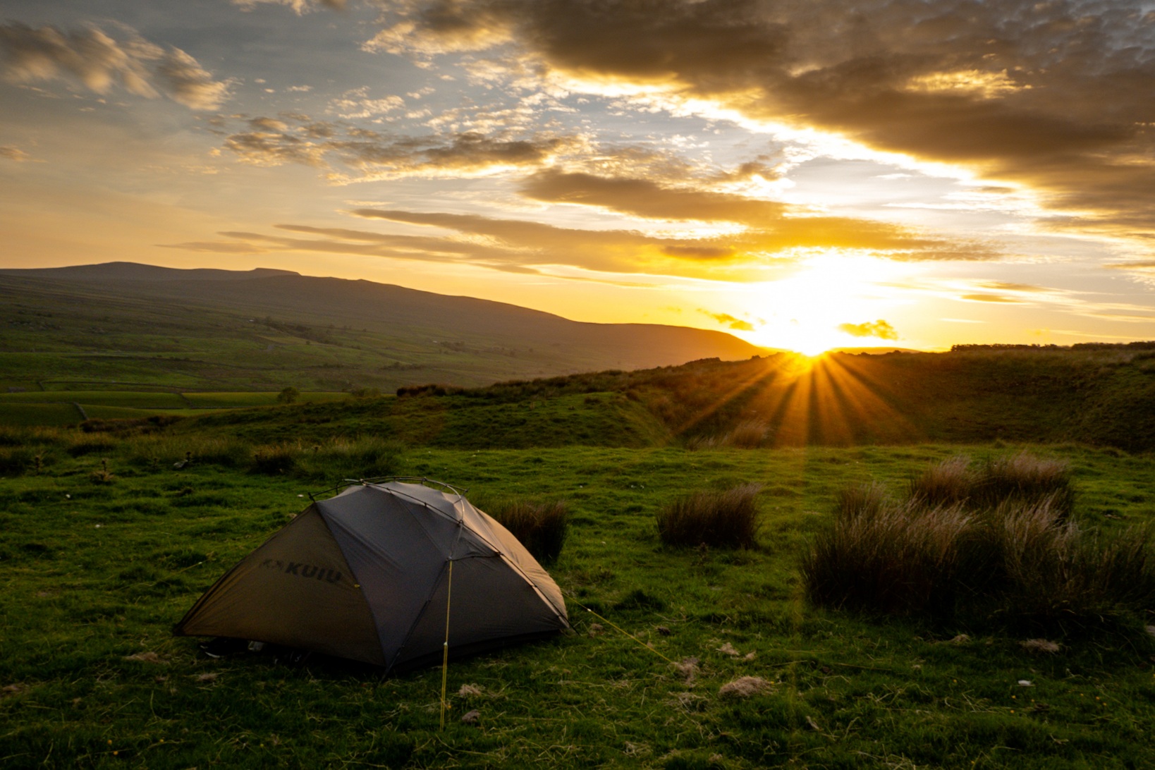
We walked through a gate and were on the Pennine Way, and it was a lot less sheepy. It was also not at all flat. There was a hill up to our left and every few metres I left my bag to run up it in search of somewhere we could feasibly stick a two human tent but it was all too tussocky or too slopey, or both. Eventually though, after a bit of searching, I found us a suitable grassy spot overlooking the village of Horton In Ribblesdale where we actually got treated to a lovely, unexpected sunset. It had been mostly overcast and brutally windy all day, but as we settled down to relieve our bags of some of their weight, the hills turned golden as the fiery skyball did the sinking thing.
STATS
Day: 1
Distance walked today: 11 miles/17.7 kms, including running up and down hills looking for a suitable camping spot. (Plus 3.32 miles/5.34 kms for the walk from the car park to the start of the trail.)
Weather: Overcast, and fuck me, that wind!
Days since shower: 0
![]() Ribblehead to Horton In Ribblesdale, North Yorkshire, England
Ribblehead to Horton In Ribblesdale, North Yorkshire, England
Stayed at: Wild Camp up a hill just before Horton In Ribblesdale
Activity: Hiking the Ribble Way, north to south.
Useful shit to know…
- The carpark we got dropped at is at 54.257304, -2.215793 / N54°15′26.3″ W02°12′56.86″. It’s a 3.2 mile walk to the trailhead from there.
- You’ll need a map as the Way isn’t marked for fucking miles, and even after that it’s only sporadically marked. The Ribble Way is indicated on OS Maps, we use a combination of the digital version of that and Maps.me.
- (Edit 2023: Maps.ME is a pile of wank now. Try Organic Maps instead.)
- There’s nowhere to resupply until you get to Horton In Ribblesdale. There are plenty of places you can filter water from streams though.
BUDGET
Groceries: £23.74 each. Enough food and snacks for the whole five days.
